I just attended an ACDSee sponsored Webinar regarding "Image Management In The Corporate World." I don't know why I was invited, since I am DEFINITELY an amateur when it comes to photography. My name must have cross 'contaminated' some mailing list, I guess. However it happened, I hope it happens again!
But I'm glad I did attend. I learned a LOT about Image Management in general, and the ACDSee products in particular.
And one of the things I learned about was ACDSee 18 and its ability to set the geo codes in the EXIF long after the photo was taken. Actually, it works with ACDSee Pro 8 and ACDSee Ultimate 8 as well.
The quick explanation is that ACDSee can use Google maps to attach a location to a given photo, then at the click of a button look up the geo code information on Google maps and insert it not only into the EXIF data, but place the conventional street address into the IPTC data as well.
I tried to duplicate this in ACDSee Ultimate 8 just to make sure it works, and it does! This sort of thing may work with photo management software other than ACDSee, but these are the tools I use and care about, so you might want to pay some attention to the more obscure tools in your favorite software.
Here is how I did it. As Always with Blogspot, you can click on any picture to make the photo bigger.
Above, I selected a photo to add geocodes
to. Then I right clicked on the photo and selected "Map|Place on Map". I could have just as easily selected tools from the menu at the top, but I didn't.
A window appears with Google Maps displayed, zoom in on the location where you recall that you took the photo. The little bubble pointer will allow you to see where the location was placed. Once you have the pointer placed the way you want it, then click on the button called "Reverse GeoCode".
A pop-up window appears confirming your placement. If it is correct, click "Save".
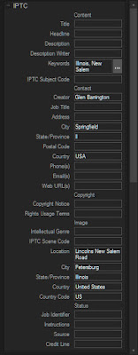
Note that the Geocode appears in the EXIF data. Also note below that the conventional street data also appears in the IPTC data.
 Now, not everyone will likely want or need this functionality, but for those who do, this will be a great convenience for them. I don't always need this sort of information. But when I do, it's a real pain to recreate it after the fact. And while I may not really want the actual geocode when a simple street address might do, as I recall the webinar speaker claimed an an accuracy to within 3 meters. I should think this would provide a lot of functionality for many people!


No comments:
Post a Comment